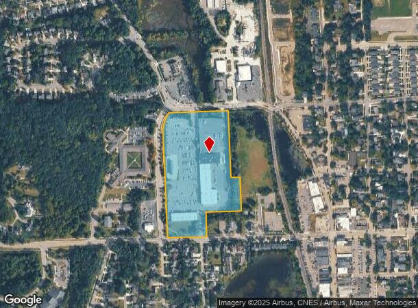
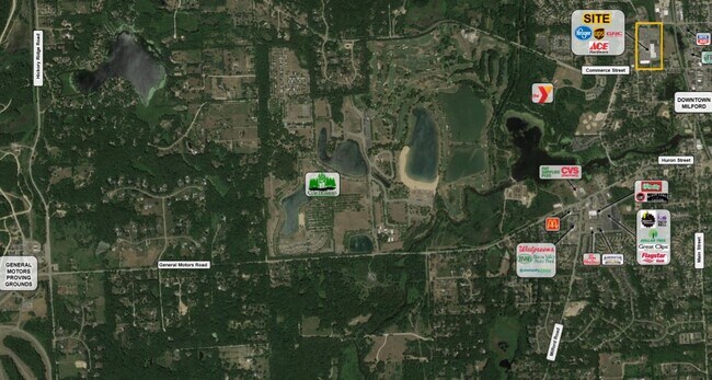
Property Record
580 Highland Ave, Milford, MI 48381

NEARBY LISTINGS FOR SALE OR LEASE
Property Detail
580 Highland Ave
Detroit-Warren-Dearborn, MI
Phelp's Add
16-10-227-020
T2N, R7E, SEC 10 PHELP'S ADD N 64 FT OF LOT 4, ALL OF LOTS 5 TO 10 INCL, N 64 FT OF LOT 11 BLK 25, ALSO 1/2 OF VAC CABINET ST
Supermarket
Oakland
X
Michigan
26125C0453F
1-16
2024
12.57 AC
2025
Central I-96 Corridor
132700
Detroit
117,504 SF
DEMOGRAPHICS near 580 Highland Ave
1 Mile
3 Mile
5 Mile
2024 Total Population
6,538
16,535
44,928
2029 Population
6,478
16,363
44,727
Pop Growth 2024-2029
(0.92%)
(1.04%)
(0.45%)
Average Age
44
44
42
2024 Total Households
2,822
6,532
16,985
HH Growth 2024-2029
(0.96%)
(1.06%)
(0.49%)
Median Household Inc
$91,957
$111,116
$106,160
Avg Household Size
2.30
2.50
2.60
2024 Avg HH Vehicles
2.00
2.00
2.00
Median Home Value
$346,389
$388,284
$360,078
Median Year Built
1981
1986
1990
Nearby Places
Map Layers
Map Styles
 Street
 Aerial
- Restaurants
- Banks
- Shops
- Fitness
- Groceries
PUBLIC TRANSPORTATION
AIRPORT
Bishop International
DRIVE
WALK
Distance
Bishop International
54 min
36.0 mi
Detroit Metro Wayne County
DRIVE
WALK
Distance
Detroit Metro Wayne County
52 min
40.6 mi
Freight Ports
Port of Toledo
DRIVE
WALK
Distance
Port of Toledo
101 min
82.2 mi
SALE & LEASE HISTORY
LISTING DATE
SALE/LEASE

Mar 22, 2018
For Lease
Nearby Properties
Address
Land Use
TOTAL SIZE
Lot Size
Zoning
Address
Land Use
TOTAL SIZE
Lot Size
Zoning
89,974 SF
Address
Land Use
TOTAL SIZE
Lot Size
Zoning
70,308 SF
2.43 AC
Address
Land Use
TOTAL SIZE
Lot Size
Zoning
77,287 SF
1.62 AC
Address
Land Use
TOTAL SIZE
Lot Size
Zoning
70,463 SF
7.98 AC
AI
Address
Land Use
TOTAL SIZE
Lot Size
Zoning
55,844 SF
5.90 AC
AI
Address
Land Use
TOTAL SIZE
Lot Size
Zoning
72,727 SF
10.51 AC
Address
Land Use
TOTAL SIZE
Lot Size
Zoning
603.37 AC
FC
Address
Land Use
TOTAL SIZE
Lot Size
Zoning
71,793 SF
5.06 AC
II
Address
Land Use
TOTAL SIZE
Lot Size
Zoning
26,054 SF
7.90 AC
AV
Address
Land Use
TOTAL SIZE
Lot Size
Zoning
19,596 SF
3.78 AC
Address
Land Use
TOTAL SIZE
Lot Size
Zoning
25,641 SF
4.89 AC
AI
Address
Land Use
TOTAL SIZE
Lot Size
Zoning
22,609 SF
5.06 AC
BI
Address
Land Use
TOTAL SIZE
Lot Size
Zoning
14,689 SF
2.05 AC
BI
Address
Land Use
TOTAL SIZE
Lot Size
Zoning
67,936 SF
9.68 AC
BI
Address
Land Use
TOTAL SIZE
Lot Size
Zoning
41,748 SF
2.20 AC
AI
Address
Land Use
TOTAL SIZE
Lot Size
Zoning
34,464 SF
7.45 AC
AI
Address
Land Use
TOTAL SIZE
Lot Size
Zoning
31,676 SF
3.59 AC
BI
Address
Land Use
TOTAL SIZE
Lot Size
Zoning
45,600 SF
3.44 AC
BI
Address
Land Use
TOTAL SIZE
Lot Size
Zoning
37,646 SF
7.53 AC
SI
Address
Land Use
TOTAL SIZE
Lot Size
Zoning
12,544 SF
0.18 AC
Address
Land Use
TOTAL SIZE
Lot Size
Zoning
27,854 SF
2.08 AC
AI
Address
Land Use
TOTAL SIZE
Lot Size
Zoning
22,605 SF
3.79 AC
BI
Address
Land Use
TOTAL SIZE
Lot Size
Zoning
5,471 SF
1.65 AC
BI
Address
Land Use
TOTAL SIZE
Lot Size
Zoning
9,891 SF
1.13 AC
BI
Address
Land Use
TOTAL SIZE
Lot Size
Zoning
13,470 SF
0.85 AC
BI
Address
Land Use
TOTAL SIZE
Lot Size
Zoning
9,959 SF
1.88 AC
BI
Address
Land Use
TOTAL SIZE
Lot Size
Zoning
44,893 SF
22.58 AC
MM
Address
Land Use
TOTAL SIZE
Lot Size
Zoning
10,404 SF
2.08 AC
BV
Address
Land Use
TOTAL SIZE
Lot Size
Zoning
10,856 SF
1.69 AC
BI
The World's #1 Commercial Real Estate Marketplace
Connect with us
© 2025 CoStar Group
The information above has been obtained from sources believed reliable. While we do not doubt its accuracy we have not verified it and make no guarantee, warranty or representation about it. It is your responsibility to independently confirm its accuracy and completeness. Any projections, opinions, assumptions, or estimates used are for example only and do not represent the current or future performance of the property. The value of this transaction to you depends on tax and other factors which should be evaluated by your tax, financial, and legal advisors. You and your advisors should conduct a careful, independent investigation of the property to determine to your satisfaction the suitability of the property for your needs.